


PRECINCT CANAAN EAST, Madison County, Ohio
About
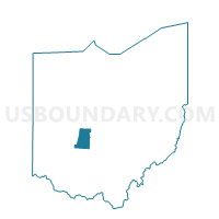
Outline

Summary
| Unique Area Identifier | 649408 |
| Name | PRECINCT CANAAN EAST |
| County | Madison County |
| State | Ohio |
| Area (square miles) | 9.31 |
| Land Area (square miles) | 9.28 |
| Water Area (square miles) | 0.03 |
| % of Land Area | 99.68 |
| % of Water Area | 0.32 |
| Latitude of the Internal Point | 40.06563130 |
| Longtitude of the Internal Point | -83.27167290 |
Maps


Graphs
Select a template below for downloading or customizing gragh for PRECINCT CANAAN EAST, Madison County, Ohio


Neighbors
Neighoring Voting District (by Name) Neighboring Voting District on the Map
- BROWN-A Voting District, Franklin County, OH
- BROWN-B Voting District, Franklin County, OH
- COLS 69-I Voting District, Franklin County, OH
- PRECINCT CANAAN WEST, Madison County, OH
- PRECINCT DARBY, Madison County, OH
- WASHINGTON Voting District, Franklin County, OH
Top 10 Neighboring County Subdivision (by Population) Neighboring County Subdivision on the Map
- Columbus city, Franklin County, OH (770,122)
- Darby township, Madison County, OH (4,226)
- Canaan township, Madison County, OH (2,567)
- Brown township, Franklin County, OH (2,293)
- Washington township, Franklin County, OH (1,549)
Top 10 Neighboring Place (by Population) Neighboring Place on the Map
Top 10 Neighboring Unified School District (by Population) Neighboring Unified School District on the Map
Top 10 Neighboring State Legislative District Lower Chamber (by Population) Neighboring State Legislative District Lower Chamber on the Map
Top 10 Neighboring State Legislative District Upper Chamber (by Population) Neighboring State Legislative District Upper Chamber on the Map
Top 10 Neighboring 111th Congressional District (by Population) Neighboring 111th Congressional District on the Map
Top 10 Neighboring Census Tract (by Population) Neighboring Census Tract on the Map
- Census Tract 62.30, Franklin County, OH (13,127)
- Census Tract 80, Franklin County, OH (5,410)
- Census Tract 401.02, Madison County, OH (5,091)
- Census Tract 401.01, Madison County, OH (2,282)